

O-Level Geography Maps
Maps of Pakistan and Major Processes:
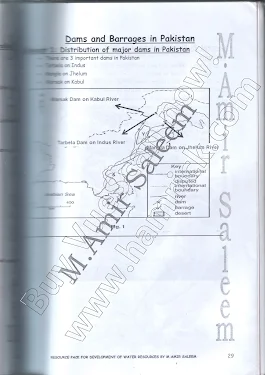
Map of Major Dams in Pakistan:
How is Electricity produced through HEP (Diagram):

How Electricity is Produced in Nuclear Power Plant (Diagram/Image):

Railway Routes in Pakistan Map:

Route of Western Depression in Pakistan Map:

Semi-Arid Climatic Zone Map:

Cement Making Process Diagram:

Highland Climatic Zone

Map showing Direction and Distribution of Monsoon Rain in Pakistan:

Demographic Transition Model Diagram:

Map showing the distribution of Forest in Pakistan:

Map of Location of Western Mountains in Pakistan:

Main Deserts of Pakistan Map

Mountains of Pakistan:

Major Cities of Pakistan Map:

Latitudinal and Longitudinal Location of Pakistan on a Map:
Scanned from notes of M.Amir Saleem
Compiled by Sohaib Bazaz


deliverance ministry
ReplyDeletedeliverance ministry
deliverance ministry
deliverance ministry
deliverance ministry
deliverance ministry
deliverance ministry
deliverance ministry
deliverance ministry
deliverance ministry
deliverance help
deliverance help
deliverance help
deliverance help
deliverance help
deliverance help
deliverance help
deliverance help
deliverance help
deliverance help
deliverance help
SRA victims
SRA victims
SRA victims
SRA victims
SRA victims
SRA victims
SRA victims
SRA victims
Have you ever wondered how many deserts of Pakistan? Or how many noteworthy barren lands in our country? Pakistan consists of 5 major deserts in the region.
ReplyDelete